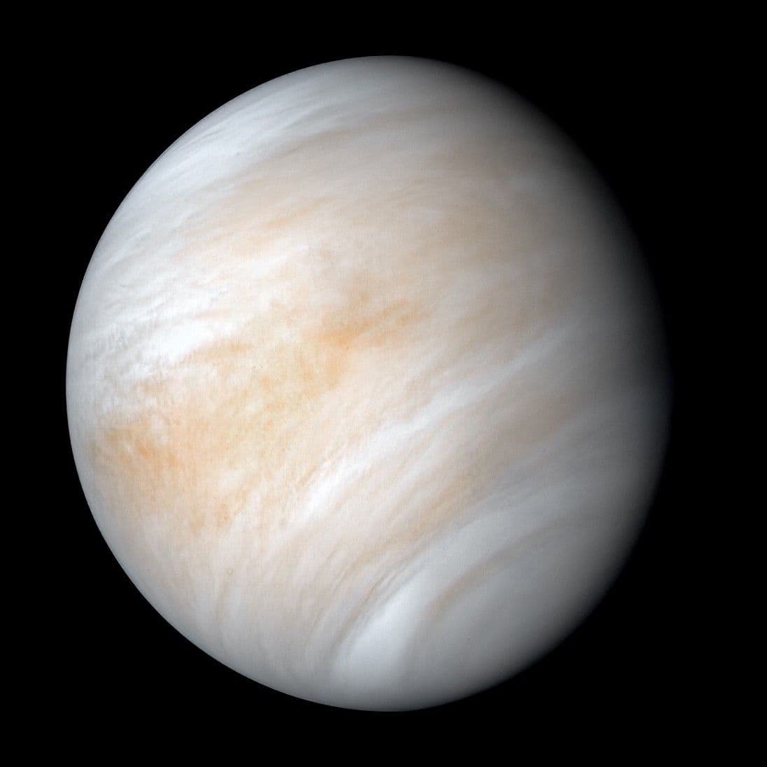
Beneath the clouds, a scorching rocky world
Venus is close to Earth in size, but conditions at its surface are entirely different. A dense carbon dioxide atmosphere traps heat, and clouds conceal the terrain from ordinary optical cameras. Surface details are reconstructed using radar and lander data.
Venus: key facts
- Type
- Rocky planet
- Mean radius
- 6,051.8 km
- Mean distance from the Sun
- ≈ 0.72 AU · 108 million km
- Orbital period
- ≈ 225 Earth days
- Rotation
- 243 days · retrograde
- Temperature
- ≈ +464 °C · surface
- Mass
- 4,87 × 10²⁴ kg
- Mean density
- 5 243 kg/m³
Values are rounded. The distance describes the orbit, not the current distance from Earth. For giant planets, temperature refers to a reference atmospheric level: they have no solid ground. Mean radius differs from equatorial radius.
Atmosphere and appearance
Mostly carbon dioxide. Sulfuric acid clouds hide the surface, where the pressure is about 92 times Earth's atmospheric pressure.
Volcanic plains
Lava plains, mountains and numerous volcanoes cover the surface.
Long days
A sidereal rotation takes 243 Earth days, longer than a Venusian year.
Venus beneath the clouds
Magellan's radar and the Venera landers explored its terrain.
What is inside?
Scientific model. Layer colors are illustrative; the thin crust is enlarged for clarity.
Crust
A thin rocky shell reshaped by volcanism.
Mantle
Hot silicate rock beneath the crust.
Iron core
A likely metallic core. Its state and precise dimensions remain poorly understood.
The cutaway is based on physical models and indirect measurements. It is not a photograph of the interior; in 3D, you can select each layer separately.
Natural satellites
Venus has no known natural satellites or rings.
History of discovery and exploration
Known since ancient times
Ancient observers knew Venus as a bright morning and evening star. It is one world seen on different sides of the Sun, not two separate stars.
- 1610
The phases of Venus
Galileo's telescopic observations revealed changing phases, important evidence that Venus orbits the Sun.
- December 14, 1962
The first successful planetary flyby
Mariner 2 passed Venus and studied its hot atmosphere.
- December 15, 1970
A signal from the surface
Venera 7 made a soft landing and transmitted data from the surface of another planet.
- 1975
The first look beneath the clouds
Venera 9 returned the first images of the surface. Dense clouds hide this rocky world from ordinary observations in orbit.
- 1990–1994
A radar map
Magellan studied Venus with radar. By 1992, mapping covered 98% of the surface, revealing extensive volcanic landforms.
Venera returned photographs from the ground. Magellan mapped the surface with radar.
Why a radar map differs from a photograph
Radar sends a radio signal and measures its return from the surface. Map brightness depends on material properties, roughness and viewing geometry, rather than familiar sunlight on a landscape. A bright slope therefore cannot automatically be called white rock. Check viewing direction and the product legend before comparing regions: some images display radar return, while others use colour to represent elevation.
A three-dimensional mountain view based on radar is a terrain reconstruction. It may combine measured elevation, assigned colours and a chosen perspective. This is a useful scientific way to depict cloud-hidden ground, but not an ordinary camera photograph above the same slope. Compare perspective views with overhead maps: features that look enormous from a low viewpoint can seem very different in their wider context.
Clouds do not rotate with the solid surface
A sequence of ultraviolet Venus images lets researchers follow cloud patterns. Their motion is not the rotation rate of the solid planet, because atmospheric currents transport the structures independently. As on Earth, a feature at cloud level is not a ground marker. Comparison requires the same wavelength, a known time interval and allowance for changes in the visible illuminated portion of the disk.
The visible white envelope, contrasting ultraviolet bands and radar terrain show different levels and properties of the same world. Without captions they can suggest Venus changes its entire appearance over a short interval. First establish what each instrument measured, then investigate physical connections between the observations. A high-contrast map is particularly useful for analysis but need not reproduce a colour familiar to human vision.
Testing evidence of active volcanoes
Reanalysis of archived Magellan radar observations revealed changes researchers associate with volcanic activity. The difficulty is that separate passes can view a slope from different angles. A robust test accounts for geometry, compares neighbouring terrain and examines alternatives. A brightness difference alone cannot establish that every mountain is an active volcano or date an individual flow to a particular day.
This illustrates why old measurements can yield discoveries without a new spacecraft pass. Improved models and renewed comparisons ask an archive questions that earlier work did not resolve. Distinguish three claims: volcanic landforms exist, evidence of recent changes has been found, and a particular eruption is being observed in real time. Each requires different evidence and cannot simply replace the others.
What Venus teaches through comparison with Earth
Earth and Venus have similar radii, making them valuable for planetary comparison, but their surface conditions differ profoundly. Atmospheric composition and mass, energy transport, clouds and water-loss history all matter. The convenient word twin describes only some parameters. A planet’s size alone cannot predict habitability or justify applying terrestrial pressure to a world with a very different gaseous envelope.
In the sky, Venus appears as a bright planet near the morning or evening direction of the Sun. Its changing phase follows the geometry of Earth, Venus and the Sun, not the disappearance of the cloud envelope. Compare disk size and illuminated fraction using dated observations. This is more accessible to beginners than seeking hidden ground through an ordinary telescope; radar detail remains a separate research view.
Questions and answers
What is the temperature on Venus's surface?
About 465 °C. This value refers to the surface beneath the dense atmosphere, not the upper cloud cover.
Why does Venus rotate backward?
Its rotation is retrograde relative to most planets. The origin of this state is debated in terms of tidal effects and the planet's history; there is no single simple cause that has been definitively established.
Do the photographs show clouds or ground?
Optical photographs from space usually show the cloud cover. The detailed global terrain map is based on radar observations, while photographs of the ground were taken by individual landers.
Continue exploring
The model offers a cutaway, rotation, images and a walk across reconstructed terrain. You can read the information on this page without loading 3D.
Open in the journeyAll planets and the SunSources and image
- NASA: object overview
- Exploration history · ssd.jpl.nasa.gov
- Exploration history · science.nasa.gov
- Exploration history · science.nasa.gov
- Exploration history · science.nasa.gov
- Exploration history · www.nasa.gov
- Exploration history · science.nasa.gov
- Exploration history · pds.nasa.gov
- Exploration history · www.nasa.gov
- Exploration history · www.nasa.gov
- NASA: physical parameters